Still knee-deep in exam territory but our dreams fly high ahead! Let's take a moment to compare Marble Maps to some of the other available Android Map applications. This will help us find places that need some polish, and features that we need to add.
So without further ado, Google Maps - Maps.Me - Marble Maps


Marble Maps already offers many useful features, however their presentation and organization is lacking. The most critical aspects I have identified is the lack of Bookmarks management and the difficulty of creating a route along with information on how to use these. The first of these could be solved by creating a bookmark system, with a View Bookmarks menu point in the side bar. The second requires adding an option to manage routes, by having a drop down option of adding a new stop (which should bring up a search menu, and list the available Bookmarks) along with the currently available option of clicking on the desired spot. Removing the location from the route should also have an X icon instead of a trash can as the route is temporary (while the trash can is more suited to long term elements such as the Bookmarks).
For managing routes and Bookmarks gesture based options are also available in other map applications, and can be implemented. For instance adding a right swipe gesture that removes the swiped bookmark or route location is a useful shortcut. Of course these require an undo option, as it is easy to accidentally swipe them.
So without further ado, Google Maps - Maps.Me - Marble Maps
Google Maps


- Routes have a drag & drop system for managing the order of the locations.
- A menu has frequently used options such as a quick button for reversing the order, as well as route options.

- Adding a stop can be done with through the menu, not just by clicking on the map.


- The side bar has several options, including Tips and Tricks under which a contribution option can be found, as well as a Send feedback option which is great for user made reports.

- Help menu offers a forum of problems with most frequent ones at the top.
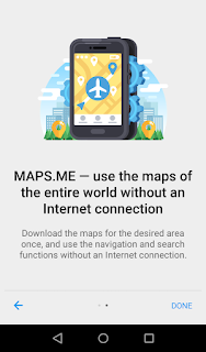
Maps.Me


- Has an Introduction that showcases some of the main features.

- Uses Empty States pattern when showing empty Bookmark Sets.


- Offers already existing empty bookmark set (My Places) and allows creation of further Bookmark sets, as well as editing already existing bookmarks.


- Offers color options to Bookmarks, also has Wikipedia links to known locations (and ads).

- Effectively communicates order of locations in a route with a Goal Flag icon

- Text fields react to presses by shrinking
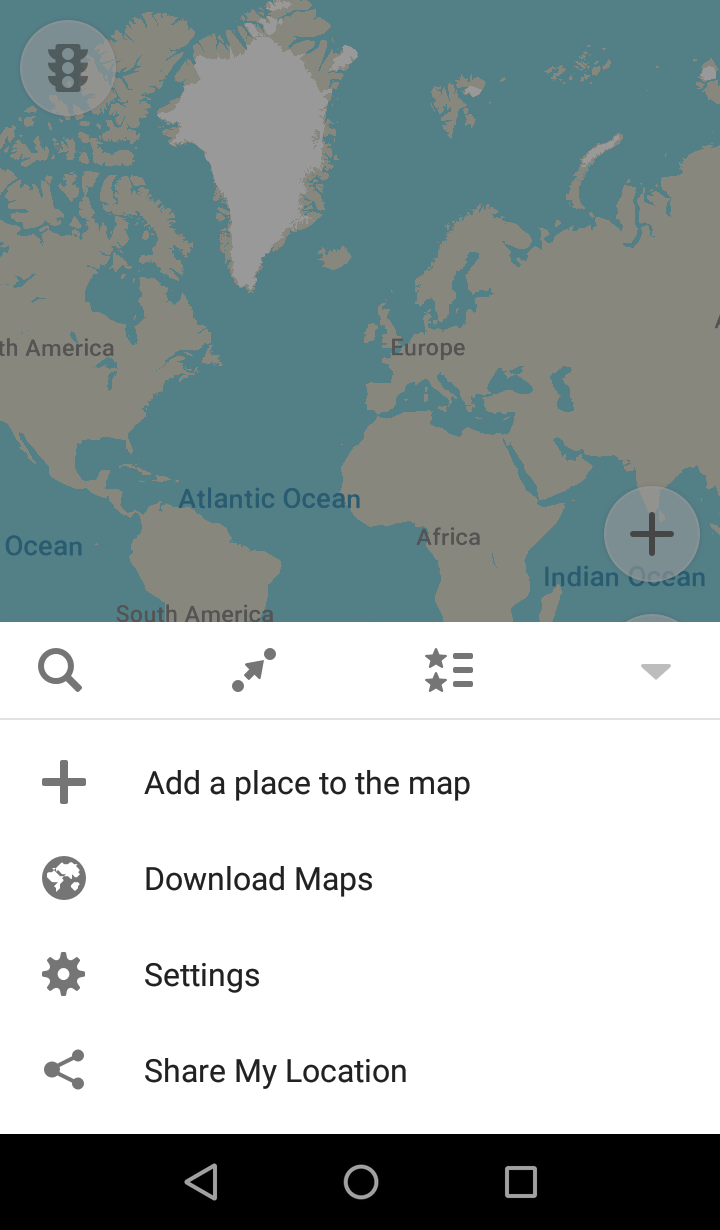

- Has a bottom drawer as navigation with Settings. Search, Routing To, and Bookmarks are the three main options always available at the bottom.


- Has progression markers on downloads and on location tracking. Searching has category filters.
Marble Maps


The side bar, which is the main navigational tool, is very lacking. While the About menu is complete and offers helpful information, there is no Help menu. Accessibility option is unclear and needs to have an option menu that highlights what it does.


I currently have at least four bookmarks, but there is no option to manage them. You can only add them to the route by clicking on them instead of having a clear option (note Google Maps) of Add Stop. Managing the order of routes is also tedious as the arrow icons to move them down are hard to use, especially on small devices.
Marble Maps already offers many useful features, however their presentation and organization is lacking. The most critical aspects I have identified is the lack of Bookmarks management and the difficulty of creating a route along with information on how to use these. The first of these could be solved by creating a bookmark system, with a View Bookmarks menu point in the side bar. The second requires adding an option to manage routes, by having a drop down option of adding a new stop (which should bring up a search menu, and list the available Bookmarks) along with the currently available option of clicking on the desired spot. Removing the location from the route should also have an X icon instead of a trash can as the route is temporary (while the trash can is more suited to long term elements such as the Bookmarks).
For managing routes and Bookmarks gesture based options are also available in other map applications, and can be implemented. For instance adding a right swipe gesture that removes the swiped bookmark or route location is a useful shortcut. Of course these require an undo option, as it is easy to accidentally swipe them.
For presenting features an introductory menu which showcases them or a help option in the side bar menu can be added. These can contain links to small tutorials on route making, setting traffic options and such.
I think this post brings up a lot of changes that will bring a huge positive change in the usability of the app. Even small changes like a better way to organize routes and bookmarks can change the overall feel of the application. I hope this post has been informative! Feel free to add your thoughts on what needs to be done! See you on the next post!
I think this post brings up a lot of changes that will bring a huge positive change in the usability of the app. Even small changes like a better way to organize routes and bookmarks can change the overall feel of the application. I hope this post has been informative! Feel free to add your thoughts on what needs to be done! See you on the next post!
Hi there!
ReplyDeleteGreat post, I am glad someone is taking up the task of improving Marble maps on android :)
It looks like it changed quite a lot, since the last time I used it. There was for example no side panel AFAIR.
One missing feature that I miss, and that is present in both other apps, is offline maps. Since we are using Open Street Maps, it should be possible to have a local copy, or an offline cache of the maps.
Then, I think that the ability to control layers (maybe with some configurable "modes"?) would be a plus as well; you don't really need highways when hiking, or bike trails when driving...
Some usability features are missing, such as 1 finger zoom (double tap and drag), or a list of the shortcuts/explanation of the UI. Technically, some people would argue that everything that needs an explanation is bad UI design; but I think that this is just because Marble UI is a bit different than what we're used to, and it needs some documentation if it stays that way.
Some things that confuse(d) me: how to place a marker (tap/long tap - marble just crashed when I did this, btw) and remove it (I currently tap somewhere else, but a new marker is placed for a seemingly-random number of times. Also the blue marker, that (I think) is supposed to indicate the current location is moving together with the view when starting the application, and is just in a fixed, random position at lower zoom levels, you might as well want to hide it.
Also; a lot of small things can be annoying, like the starting position of the view (in the middle of the ocean, south of Africa, which doesn't seem to make a lot of sense, if the device already has a GPS/GSM fix. Also, the button to center the view on the current position is nice, but the zoom level is then off: my current location is inside a circle with a 2km radius, it doesn't make sense to zoom to a point where I have 50 meters on the whole screen :) -- just adjusting the zoom level to display the red circle as 1/3 of the smallest screen direction would do, for example. Displaying a scale when zooming would be very useful as well.
A navigation mode like in car GPSs is also missing, but that's a rather large chunck of work, I think (though it has to be taken into account when designing the UI. If so, it could be surprisingly easy to implement).
A lot of problems there seems to be with Marble seem to come from the fact that Marble is originally a desktop application, and that on mobile, screen estate is really limited. It looks like you are aware of this, but it *might* (some ux testing is needed there) be a good idea to enable fullscreen mode, hide the search bar, scale, etc... when dragging the map, and show them again when tapping the screen? One side effect of having a small screen is that we often have a map without any city names, which makes orientation cumberstone at times.
This is a bit of a brain-dump regarding my impressions on Marble, I hope you will find it useful for your work, but don't feel like you *have* to address everything yourself ;)
I wish you the best luck and courage for your GSOC :)
Hi!
DeleteThank you for the very detailed response! While many issues you've mentioned have already come up and are being planned for, a lot of it comes in very handy (especially the details regarding things to fix!), the full screen feature and the layering option only came up recently, so it's great to see it requested. It's very nice to hear what areas others find to be most lacking, so it's wonderful to get responses, especially in detail.
For now the first updates to look forward to will hopefully focus giving the current features a bit more usability through the UI (Bookmarks for instance might get a nice little management option). Here's hoping we can accomplish a lot this summer.
Please look forward to the updates!
> Please look forward to the updates!
DeleteI do!
I am glad that you found the feedback helpful. Of course, not everything I wrote is in the scope of your GSOC, but I look forward to any improvement you can make regarding usability :)
Hi Judit,
ReplyDeleteI'm currently looking for an offline navigation app. I'd love to use marble, since I'm a long time KDE user. However, marble is lacking quite a bit (hence your GSOC project; thanks for taking that on). For the moment, I've settled on Mapfactor Navigator.
In principle, Maps.me has everything I need, except for warning on speed limits. Also the voice directions were sometimes confusing, telling me to head straight on when I should take an exit from the motorway.
So here are some things you may want to consider for marble:
- Display speed limits
- Accurate voice instructions for navigation
- Include information about current traffic conditions and consider that for routing.
- Automatic change from day to night mode, based on local sunrise/sunset times or on ambient light sensor.
- Automatic orientation of the map into the heading direction.
- A 3D mode for car navigation.
- Since marble is using OSM, it would be great to be able to make edits from within the app.
Just a few ideas, in case you get bored ... ;-)